A rustling in the trees and a jaguar walks into sight. Now, you probably don’t worry about jaguars when you survey your land, but for Crique Sarco village, it’s all part of the territory. Jaguars aren’t even the most dangerous threat—not by a long shot. Ever since the Maya of Belize won the right to legalize our lands, the shadow of extinction looms ever more starkly. While historians and tourists refer to the ‘lost’ Mayan civilizations across Central America, we have not disappeared. We still live through traditional governance systems that survived centuries of colonization. And yet the greatest triumphs of this Mayan generation could well be our civilization’s final downfall.
The anthropologist Liza Grandia has a deep understanding of the dangers we face. She closely followed what happened to Maya communities in El Petén province in nearby Guatemala after the 1996 Peace Accords. According to Professor Grandia, the very process of land legalization can deal the fatal blow to Indigenous communities. In her research in El Petén, she found that something terrible happened in some communities. After finally receiving their property titles, villages just disappeared.
The word ‘disappear’ is fraught with sinister meaning in Latin America. For the Maya of Guatemala, during the systematic attempt of genocide in the civil war years, disappearing meant a visceral, brutal erasure of individuals, hundreds of thousands of them. After the Peace Accords, a more efficient, yet haphazard, method of disappearance erases entire communities without wasting a single bullet.
As Grandia wrote in an analysis of the impact of $62 million World Bank investment into Indigenous land titling, “land demarcation is seen by many communities as the pivotal moment in their history.”
High among the list of what she calls “the risks of uninformed state administration” are the imposition of uniform grids of plots that ignore communal land usage, along with the lethal transformation of a spiritual land value into a commodity exchange.
Grandia describes a Guatemalan legalization process so bureaucratic—with as many as 43 steps—the State was left with more than 40,000 unprocessed land claims. The red tape was so thick that some waited years on end for property titles.
Even once they had them, the grid system destroyed communal access to rivers, roads, sacred sites, shared grazing fields, and communal forests, along with the land distribution system based on usage. Western models of land management, such as boards of directors and administrative councils, replaced traditional governance.
The Guatemalan Maya fell victim to a land rush of outsiders: large cattle plantations hungry for land and opportunistic banks with dubious agricultural credit schemes for impoverished farmers. Narco syndicates straight out blackmailed them. Stuck in a grid, unable to fully use all parts of their commons, a medical emergency was reason enough to cash out. It is estimated that at least 46 percent of all Maya land parcels in El Petén were lost in less than 10 years. At least 200 sacred sites were privatized.
Our organization, the Sarstoon Temash Institute of Indigenous Management (SATIIM), has worked with Grandia since her early research on the Q’eqchi Maya in Belize and Guatemala. She provided testimony in support of litigation that eventually led to the Caribbean Court of Justice order that our lands be legalized. Her documentation showed that our cultural practices constitute an “eco-cultural logic” that is a “means to maintain and cohere community identity, not a pathway to ‘credit-worthiness’ or as land market participants.”
Following the court order, we knew the government would not easily follow its explicit instructions to “create an effective mechanism to identify and protect the property and other rights arising from Maya customary land tenure, in accordance with Maya customary laws and land tenure practices.” We knew the cautionary tale of El Petén. So we needed to take the lead.
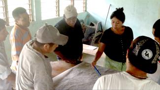
Grandia recommended we contact a Guatemalan Q’eqchi group, Sa Qa Chol Nimla K’aleb’aal (SANK), in Alta Vera Paz who developed a land demarcation model based on customary land governance. SATIIM arranged a visit for our community leaders interested in learning more. They came back inspired. Crique Sarco was the first village to ask SATIIM to train them in SANK’s model.
After much consultation, all residents of Crique Sarco signed a community resolution that SATIIM serve as their technical assistance coordinator. We brought SANK staff to train them in all aspects of mapping—not just the physical boundaries, but discussions of how land is used by individuals and the community as a whole according to their cultural practices and beliefs. It quickly became clear, however, that SANK’s model could not be copied and pasted over our reality.
We culled knowledge from communities across the globe, such as the Indigenous Peoples Alliance of the Archipelago (Indonesia), who are building a land registry in anticipation of national legislation just like we are. Our research led us to Elinor Ostrom, a Nobel Prize winner whose “Governing the Commons” delineates the vital steps beyond mapping. Learning GPS technology is not enough. Maps are just the beginning, not the end goal. Her “Eight Principles for Managing a Commons” address the essential community decisions on the cultural rules that govern communal land, along with community monitoring and enforcement.
After two years of intensive training, constant feedback, and negotiations, Crique Sarco finally has its maps. Now the real work begins. They need to elucidate—not necessarily ‘codify’ in Western legal jargon, but on their own terms— the ancient meanings of their lands. Their collective visions of communal land management will guide the politics of consensus maintained by ties of kinship and reciprocity.
They need to discuss natural resource management, especially as their families grow. Most Maya communities in southern Belize are the de facto forest rangers of commumapping nal forests, now the last tracts of highly desired timber, such as mahogany and rosewood. While 70 percent of Toledo is forested, almost 20 percent has been lost. Logging companies are always on the lookout for an opportunity. At one point, the government handed over the entire Toledo district to a U.S. oil company in one giant concession.
SATIIM is an Indigenous-led environmental organization in Belize created by communities in the Maya Golden Landscape.One of Central America’s last unbroken stretches of broadleaf forest, from the Maya mountains in the east to the Caribbean Sea, our forests play a crucial role in the defense of the Mesoamerican Barrier Reef by preserving the quality of the water draining into it. When we Maya of Belize finally won recognition of our land rights, it was not from our own government, but the highest legal authority in Caribbean Community. After close to 20 years of struggle, we celebrate this victory, and more importantly, the induction of Crique Sarco as the first entry into Belize’s Maya Land Registry.
On August 9, the International Day of the World’s Indigenous Peoples and in honor of the 10th anniversary of the UN Declaration on the Rights of Indigenous Peoples, SATIIM hosted a chutamil (traditional gathering) that presented the Maya Land Registry, the Huhil Ch’och in Q’eqchi and Hu’umil Lu’um in Mopan, to the world, the government and the nation, and most importantly, to the Maya people. We know that the wolves, if not the jaguars, are at the door. With this knowledge, we celebrate a promise that invites all Maya communities to begin the process of communal land legalization with all its perils and pitfalls.
—Froyla Tz’alam (Mopan Maya) is executive director of the Sarstoon Temash Institute of Indigenous Management in Toledo District, Belize.